Imagine 3D navigation of production facilities as easy as using Google Maps
Can 3D navigation of production facilities help you do your job better?
Imagine this scenario: You are a plant operator assigned to a new job at a manufacturing plant. Tomorrow is your first day and you are planning your drive to a destination you are not familiar with. Naturally, you type keywords into Google Maps, you filter the results, and hone in on the destination. You zoom into it, drag that little guy to get the Street View and see how your plant looks. You then click the teardrop to get some more detailed information about the location. It has only been a few minutes – you have everything you need to get yourself to work on time.
Now you are enjoying your second day at the plant. You are assigned a new task, at a post, and you need to learn everything about this station and how to operate it. Now what? You ask your supervisors and new colleagues what to do. They point you to a file cabinet. One of the colleagues remembers that they have some documents on the network, or on their hard drive. They promise to send it to you. Well, they can’t find it anymore – they have not needed the information in a long time. Oh no! Your assignment starts tomorrow and you’re thinking to yourself, ‘Why can’t I just go to Google Maps, find my post, and get all my information?’
Well, as a matter of fact, you can!What if you could log-in to a ‘Plant Information Kiosk,’ which looks very similar to Google Maps? You don’t need any instructions because this is a simple process that you have done many times before. You type in a keyword, perhaps your post name (some call it Company Address). A layout of the plant appears with a tear drop indicating the location of your post. You double click it, it zooms in, and what do you know! Now you have a good idea of how your post looks as well as the entire facility. Hey, this is just like Google’s Street View! You click a button and you check a box that seems promising (after all its title is ‘Operator’s Instructions’).A few teardrops show up on top of the Post just like in Google Maps. One of them is titled, ‘How to Operate Station 20’. This is exactly what you were asked to prepare. You double click it and a document opens. You are ready for tomorrow! And, the best part is, nobody had to tell you where to find what you needed to know. You found it yourself!
This is not some future dream for plant operators and other manufacturing people tasked with organizing manufacturing and production information so everyone else can easily find it.
This is reality. Problem solved!

Enter Intosite from the Siemens PLM Software Tecnomatix suite
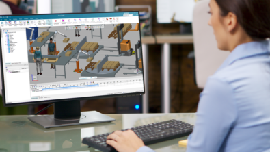
Tecnomatix Intosite software is a cloud-based web application that maintains a 3D representation of a production facility, presents it in its geographical context, and allows you to navigate through the facility in the simple and familiar way you navigate Google Maps. Intosite supports cooperation and collaboration on the shared information in your enterprise, and harnesses the “wisdom of the crowd” by enabling the sharing of best practices, tips and tricks.
Intosite provides intuitive access to information from any IT system. You can view IntoSite design, manufacturing and facilities information managed in Teamcenter, as well as the geographical location of your assets.
Intosite deploys as a Software as a Service (SaaS) application, with the software and the associated data hosted on the cloud, that you can access via a web browser. This way, you do not need to invest in hardware or manage the software installation and ongoing maintenance.
Would you like to learn more about Intosite and current applications of the software?
- Visit our dedicated Intosite web pages
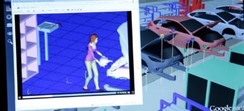
- Check out this video about a pilot project with Ford Company
- View the Intosite Overview video for a quick look at the software
- Let us know what you think in the comments section below